
Ihlara Valley
Ihlara Valley is a green canyon in Aksaray Province, cut by the Melendiz River through soft volcanic rock. Its steep walls, riverside vegetation and rock-cut churches make it one of the most distinctive landforms of the wider Cappadocia region.
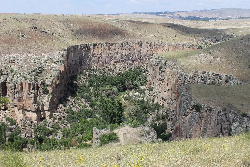
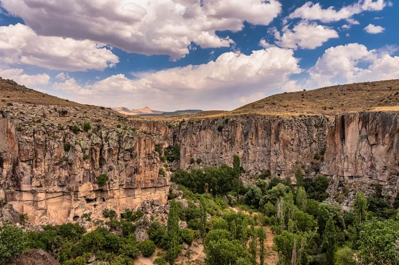
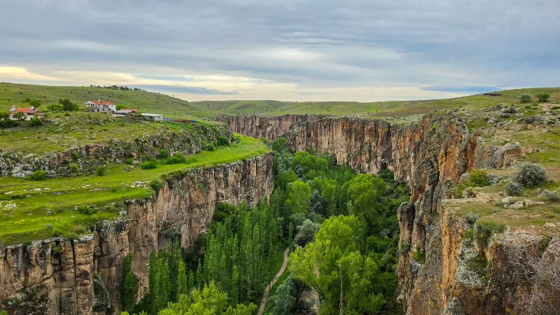
Ihlara Valley is a canyon in the Güzelyurt district of Aksaray Province, in the interior of central Türkiye, carved by the Melendiz River through soft volcanic rock. It stretches roughly 14 kilometres between the village of Ihlara at its southern end and the village of Selime at its northern end, and in places the canyon walls rise around 100 metres above the stream. Although the valley lies outside Nevşehir Province, it is generally treated as part of the wider Cappadocia region, and what sets it apart from the dry, open valleys further north is the combination of a stream that flows all year, dense vegetation on the canyon floor and near-vertical rock faces on both sides.
Where the valley lies
The canyon runs across a volcanic plateau in the northern part of Aksaray Province, south-west of the Melendiz Mountains and to the north-west of the Hasandağı volcanic massif. Ihlara village sits at the southern entrance, Belisırma lies partway along the floor, and the canyon continues north towards Selime and Yaprakhisar. The nearest city is Aksaray, roughly 40 kilometres away by road; the small town of Güzelyurt is a short drive from Ihlara village and serves as the other main base for the area. Above the canyon rim the land is open, dry farmland and steppe, which makes the sudden drop into a wooded gorge all the more pronounced.
How the canyon was formed
The plateau here is built from layers of volcanic tuff and ignimbrite, material thrown out by eruptions of the region's volcanoes, including Hasandağı and the Melendiz volcanoes, and later compacted into relatively soft rock. The Melendiz River, working its way north over a long period, cut a deep trench through these layers. Because tuff erodes easily but stands in steep faces when undercut, the river produced a narrow canyon with sheer walls rather than a broad, gently sloping valley. Harder bands within the volcanic sequence and the occasional capping of harder lava influence where the walls stand firm and where they crumble.
The river and the green floor
The stream on the canyon floor is fed by springs and by meltwater from the higher volcanic ground around it, and it carries water through the year. That constant supply explains the contrast between the rim and the floor: poplars, willows, orchards and small plots of cultivated land line the water, while the plateau above is largely bare. The vegetation creates a shaded corridor that is noticeably cooler than the exposed farmland during summer and slightly milder than the rim in winter. This green ribbon, visible from the plateau edge, is the valley's most recognisable natural feature.
Rock-cut churches in the canyon walls
The same soft tuff that made the canyon easy to erode also made it easy to excavate, and the walls contain a large number of rock-cut churches and dwellings, many of them decorated with frescoes. Examples include the Ağaçaltı, Kokar, Sümbüllü, Yılanlı and Kırkdamaltı churches, several of them reached by steps or short ledges cut into the rock face. Most of the painting is dated broadly to the middle Byzantine period, roughly the 9th to 11th centuries, with older and later phases in places. The churches are registered monuments, and the frescoes are fragile.
How the valley changes through the year
Spring is when the canyon is at its fullest: snowmelt from the surrounding high ground raises the stream, the floor turns vividly green and the slopes above carry wild flowers. Summer leaves the plateau hot and dusty, but the canyon floor remains shaded and humid, and the river runs lower as the season advances. Autumn brings mild weather and colour along the water, with the poplars and other deciduous trees turning yellow before they lose their leaves. In winter the rim can hold snow while the floor stays comparatively sheltered, and the steep stone steps and shaded sections of path can become icy and slippery. Rain in any season makes the rock surfaces in the canyon more slippery than they look.
Walking the valley floor
The canyon is explored on foot, following a path that runs beside the stream. Terrain is uneven rather than technically difficult: earth, stone, loose gravel and sections where the route crosses the water on small bridges or stepping points. Walking the full length of the canyon takes most of a day; many people cover a shorter section instead, entering and leaving at the villages. Descending from the rim is the physically demanding part, because the entry points involve long flights of steps, and the climb back out is steady work in warm weather. Sturdy shoes with grip are more useful here than light trainers.
Reaching the valley
Access is by road. From Aksaray, routes run through the countryside to Ihlara village, where a stepped path drops from the rim into the canyon. Other entrances exist at Belisırma on the valley floor and further north near Selime, so the canyon can be walked in one direction and exited at a different point. Public transport in the area is limited, and most visitors arrive by private vehicle or as part of a wider journey through the Cappadocia region. Distances between the villages are short on a map but involve slow driving on rural roads.
Practical natural conditions
There is little shade on the plateau and none at all on the descent, so sun protection and water matter even on mild days. The river water is not intended for drinking. The rock is soft enough to crumble, and the floors and ceilings of the excavated spaces are worn, so care is needed in and around the churches; touching or wetting the frescoes causes real damage. Ihlara Valley is a protected area, and its combination of geology, hydrology and historic carving is the reason for that status rather than any single feature alone.
Related natural landscapes nearby
The volcanic cone of Hasandağı rises to the south-east and forms the backdrop to much of the plateau around the canyon. The Melendiz Mountains lie to the east, feeding the streams that cut the gorges of this part of Aksaray. North of the valley, the rock-cut settlement and formations around Selime and Yaprakhisar continue the same geological story, and further north-east the valleys of the Cappadocia region around Nevşehir show similar tuff landscapes in a drier setting. Güzelyurt, close to the southern entrance, sits among its own small valleys and rock dwellings.
Beaches & bays
See the coast →
Related content
Aksaray
Explore Aksaray, Central Anatolia: history, standout sights, landscapes, local food and practical travel advice for an unforgettable journey in Türkiye.
Cappadocia
Cappadocia is a region of Central Anatolia in Turkey defined by eroded volcanic tuff, rock-cut Byzantine churches and multi-level underground cities. This guide explains how the landscape formed, what the main valleys and sites actually contain, and what to know before visiting.
Nevşehir
Nevşehir is a provincial capital in Central Anatolia and the main urban base for the rock landscapes, underground settlements and balloon flights of the Cappadocia region.
2-Day Cappadocia Underground Cities Route
A two-day route from Nevşehir through the underground cities of Kaymaklı and Derinkuyu, finishing with a walk through the Ihlara Valley and the rock-cut complex at Selime.
Ihlara Valley
Ihlara Valley is a 14-kilometre canyon in Aksaray Province cut by the Melendiz River, lined with Byzantine rock-cut churches and frescoes. This guide covers its geology, the churches inside it, the walking route and the best time to visit.
4-Day Cappadocia to Konya Route
A four-day southbound route from Cappadocia's rock-cut valleys to Konya, linking the underground cities of Derinkuyu and Kaymaklı, the Ihlara canyon, Selime Monastery and the Mevlana Museum. It is a linear, self-drive journey across the volcanic plateau of Central Anatolia into the Konya plain.